
Natural Flood Management
The aim of the project is to hold back water in upstream areas by applying natural methods in order to 'slow the flow' of water.
The Worcestershire Natural Flood Management (NFM) project is one of 24 catchment scale projects funded by the recent £15m DEFRA allocation for NFM projects in England. The Worcestershire project has been allocated £500,000, (with the business case signed off up to £750,000) and is due to be completed by March 2021.
The aim of the project is to hold back water in upstream areas by applying natural methods in order to 'slow the flow' of water. It is thought that by applying a catchment based approach, rather than just looking at river flow independently will have a positive effect on reducing flooding.
Three areas which are known to suffer from flood risk and water quality issues, and thought to benefit from NFM techniques have been identified within the region. These are; the Dowles Brook in the Wyre Forest, Barbourne Brook in Worcester City and the Cotswold tributaries, which consist of the Badsey Brook, Merry Brook and the River Isbourne.
Each area will be studied independently and working alongside partnership organisations such as the Environment Agency, Wildlife Trusts, Forestry Commission, Local Authorities, local residents, Flood Action Groups and landowners the aim will be to apply natural methods of water retention to reduce flood risk. This could be achieved in a number of ways, but primarily by the use of three methods:
- Physical Barriers: Such as a succession of leaky dams to upstream areas of a watercourse (large trees placed across a watercourse to give a damming effect)
- Attenuation: Allowing low lying areas to flood upstream – holding back the water and so slowing the time water takes to travel down the river's course
- Infiltration: Simple methods, such as tree planting are thought to greatly increase the infiltration rate, or using soakaways in upstream areas should the ground conditions allow
The project aims to use a combination of these methods across each catchment and working closely with landowners, farmers and communities devise a natural flood management technique that will reduce flood risk and enhance the natural environment.
Cotswolds tributaries
River Isbourne
Beesmoor Brook, a major upstream tributary of the River Isbourne
Download a map of the Beesmoor Brook area
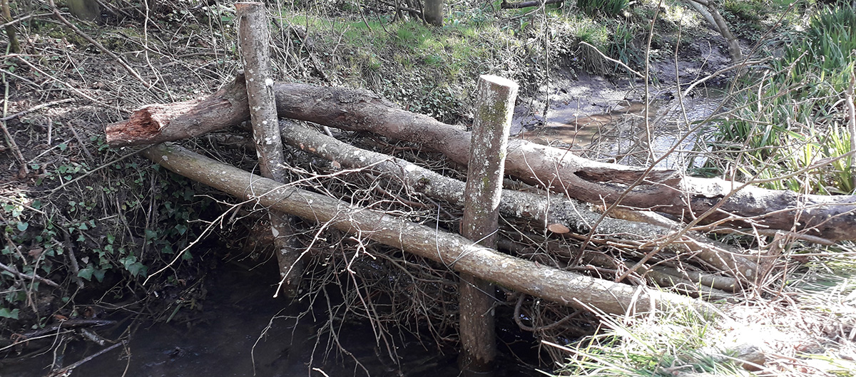
In spring 2019, eight large woody structures were installed along a stretch of the Beesmoor Brook, at Waterhatch, Charlton Abbotts. The structures were of two designs; the first consisting of a number of locally sourced tree trunks (Ash and Alder) coppiced and placed across the watercourse, and onto the river banks. The second consisting of hazel bundles, which used much smaller, hazel trees coppiced and tied together in a bundle and attached to a 'hazel frame' secured into the river bed. The type of structure used was determined by the riparian conditions i.e. what trees were apparent and whether river banks were steep-sided, or shallow and flat.
Although there were different dam types, both have the same benefits and are built in such a way that base and low flows are unimpeded, meaning wildlife and fish can also get through, but during times of higher flows the dams slow the flow of water travelling downstream, increase upstream attenuation and trap sediment.
During high flows each dam will slow the flow and hold back water in upstream areas, so decreasing the amount of water travelling downstream. Collectively with other NFM features within the catchment this will reduce flooding for downstream communities. Other benefits will include the development of increased wetland areas, which will lead to an increase in biodiversity and habitat formation. Water quality should also be increased due to the trapping of sediment.
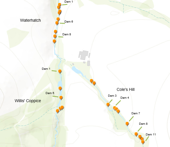
In September 2019 a further 19 dams were built upstream of the previous 9 at Waterhatch. 11 are located on the Cole’s Hill tributary and a further 8 at Willis’ Coppice. This gives us a total of 28 dams in place on the Charlton Abbotts Estate.
A map showing the 28 dams:
Contact has been made with landowners further downstream on the Beesmoor Brook, and it is hoped that further dams will be implemented in Spring 2020.
Download a map of current dam locations
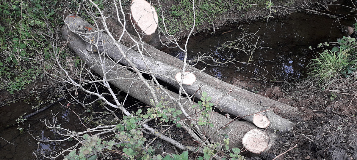
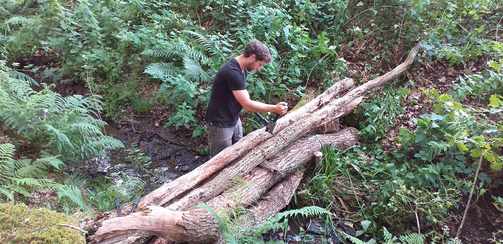
Examples of the leaky woody structures in the Beesmoor Brook:
Snowshill
Download a map of the Snowshill site
NFM landscaping work has been undertaken at a farm in Snowshill. This is at the top of the catchment, where the slopes are extremely steep and run-off is a major problem during heavy rainfall events. The work undertaken involved re-shaping the landscape to divert water to naturally low lying areas. This was achieved by the use of scrapes and small attenuation bunds. Scrapes were undertaken in order to divert water from the hillside to low-lying natural depressions. Stored water in these natural depressions will naturally Infiltrate and so be ‘removed’ from the system.
There are also several springs flowing through the area; 150mm diameter pipes were installed at the low point to allow a base flow at all times, with clay bunds created to attenuate and hold back the water during high flow events. The clay was obtained from upstream of the bund, so creating a depression/storage area and the bunds were tied in to high ground on either side.
Merry Brook
Download a map of the Merry Brook area
In Spring 2019 seven woody structures were installed in the Merry Brook. Each structure consists of a number of locally sourced tree trunks (Ash and Alder) and branches which will allow base and low flows to pass unimpeded, but interact with elevated flows to increase upstream attenuation and trap sediment. During high flows each dam will slow the flow and hold back water in upstream areas, so decreasing the amount of water travelling downstream. Collectively with other NFM features within the catchment this will reduce flooding for downstream communities. Other benefits will include the development of increased wetland areas, which will lead to an increase in biodiversity and habitat formation. Water quality should also be increased due to the trapping of sediment.
Examples of the leaky woody structures in Merry Brook:
Dowles Brook catchment
Work has commenced to slow the flow through the catchment of the Dowles Brook, with leaky wooden dams and woody debris interventions being placed in the upper tributaries in an attempt reduce the flash flood nature of many of the brooks and ditches where water shoots off the land too fast. The interventions slow the movement of water holding it for longer in the upper catchment and so spreading the peak flow over a longer period. As of July 2019 the first 20 structures have gone in and over the next two years of the project a wide range of interventions across the catchment are planned which it is hoped will result in a reduction in the speed at which the water travels through the catchment.
 Facebook
 X
X Email
Email WhatsApp
 Messenger