
Ronkswood Active Travel Routes
These works form part of our commitment to improving walking and cycling routes across the county, and will include brand-new resurfaced routes; offering enhanced provision for cyclists and pedestrians travelling in the area and beyond.
We want your feedback
We would like your feedback on two proposed active travel routes.
Active travel routes provide practical, convenient ways of getting around, they also aim to encourage people to improve their health and fitness, help to reduce traffic congestion and enhance air quality.
These routes are being delivered in partnership with Worcester City Council.
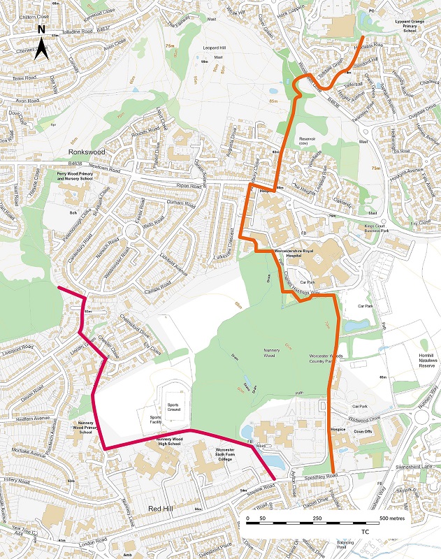
Route one
Route one, will take you from Spetchley Road, round the back of Worcester Sixth Form College, past the Nunnery Wood Sports Complex towards Nunnery Lane.
The proposed route then goes round next to the sports field and onto Newcastle Close, turning left on Chelmsford Drive towards Liverpool Road and linking into routes in Perry Wood Local Nature Reserve.
Route two
Route two, will take you from Spetchley Road up past St Richards Hospice and County Hall car park into the Worcester Woods Country Park, towards the Worcestershire Royal Hospital.
The route will then arc round the hospital site, alongside Charles Hastings Way, and then link up with Newtown Road. The route then continues up Oakmont Drive, towards Woodgreen Drive, across the road, where a new Toucan Crossing will be installed, and up towards Lyppard Grange Local Nature Reserve.
Tell us what you think
We would like any thoughts you have about these routes, how they could be improved, how they could link in with the wider area or any other comments that could help us in the development of these routes.
Please provide your comments to MIP@worcestershire.gov.uk
 Facebook
 X
X Email
Email WhatsApp
 Messenger