
Completed flood alleviation schemes
Information on the programme of schemes to reduce the risk of flooding on key sections of the highway network throughout the county to ensure the county is kept open for business.
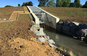
Badsey Brook
Broadway, Childswickham and Murcot were severely flooded in 2007 following record breaking rainfall across the area and the villages were again flooded in 2012. The new flood storage area, sited at an 18 acre field in Broadway, will be able to hold up to 135,000 cubic metres of water during times of flood and will only allow a set amount of water to flow downstream at times of intense and high rainfall. This will reduce flood risk to 57 properties in Broadway and 215 properties in Childswickham and Murcot.
The Badsey Brook flood risk management scheme has been delivered as part of the Environment Agency’s £2.6b capital investment programme to reduce flood risk to 300,000 homes by 2021.
The Environment Agency, Worcestershire County Council, Wychavon District Council, Broadway Parish Council and Childswickham Parish Council worked in partnership to secure over £2 million of Government Grant in Aid funding towards the scheme. The Environment Agency’s English Severn and Wye Regional Flood and Coastal Committee also contributed £1.2million. Worcestershire County Council and Wychavon District Council and the local parishes contributed the remaining £900,000.
As a condition of the planning application, detailed archaeological investigations, part funded by Worcestershire County Council, were carried out at the site, unearthing evidence of settlements dating back around 8,500 years. Finds included a beaker dating from around 2,000 BC and skeletons of a mother and baby.
For more information, please visit: GOV.UK: Flood risk management scheme for Worcestershire village opens
Upton
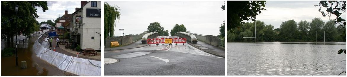
In 2007, Upton upon Severn was so badly hit by flooding, it was reduced to an island. More recently in 2014, the A4104 road had to be closed for several days due to flooding and the only way to access the town was by boat or army truck
This flood alleviation scheme in Upton forms part of a programme of schemes from Worcestershire County Council to reduce the risk of flooding on key sections of the highway network.
The main aim being to keep residents and businesses moving during flooding and keep Worcestershire 'Open for Business'. The majority of funding for this scheme comes via the Local Growth Fund through the Worcestershire Local Enterprise Partnership. It is the latest of several hundred flood alleviation and drainage schemes implemented by the County Council since 2007.
Once completed, the scheme will have raised over 500 metres of the A4104 in Upton between A38 and the Marina by up to 0.8 meters (2.5ft). This will mean the road will be able to remain open for longer during floods, even if water levels reach that of 2014. In addition the road was widened, footways improved and drainage from surrounding fields improved along with a new, better turn lane into the Marina.
Overview of Scheme
Once complete, the scheme will have raised over 500 metres of the A4104 in Upton between A38 and the Marina by up to 0.8 meters (2.5ft). This will mean the road will be able to remain open for longer during floods, even if water levels reach that of 2014. In addition the road is set to be widened, footways improved and drainage from surrounding fields improved along with a new, better turn lane into the Marina.
To minimise the impact of the scheme on traffic during the important local festival season, completion of the works has been phased:
Phase 1 was completed ahead of schedule at the end of. This phase included raising and widening of the road, a new right turn filter lane installed for the Marina as you come over the bridge and the creation of a new wider footway.
Phase 2 also completed ahead of schedule in order to move offsite before the main festival season in the area began. This phase concentrated on the raising and widening of the road in the Holly Green area..
Phase 3 began in September and involves the installation of new culverts under the road to help with draining in addition to extending and strengthening the existing culverts.
For travel updates please follow us on Twitter using @worcstravel.
Statement from Mr Mike Ostick (Vice Chair, Upton Business Association)
"Up until 2012, with 70 floods in forty years, Upton upon Severn was dubbed “the most flooded town in England”. With the 2007 floods many traders suffered once more from the cost of flood damage and great losses of business. The town was uninsurable, and the local economy was in potentially terminal decline. Then due to business and community pressure, and with Government support, the flood defence schemes were completed in 2011 [New Street] and 2012 [Waterfront].
"These defences brought a return of business confidence, and ever increasing private investment in our local economy. However the 2014 floods, with an Army shuttle the only access from the north, showed we were not yet resilient enough as a town to continue our economic revival. The closure of the A4104 near Ryall resulted in a near 50% drop of in economic activity. The town needed not only to be dry, but also accessible to the greater Upton area.
"Again with local business pressure, and strong support from local MP Harriett Baldwin, the raising of the A4104 became a reality. This will give us a more flood resilient town with ensured access north to south along the A4104. It enables sustainable community growth, both north and south of the town, giving more local consumers, and further developing the foundations of our local economy.
"Since the flood defences, we have gradually improved our shop occupancy levels significantly above that of the majority of small market towns, and seen a real increase in private investment in developing shops and offices. Better flood security for the A4104 is the final infrastructure development that ensures a basis for growing the local economy, to the benefit of our residents and traders alike."
 Facebook
 X
X Email
Email WhatsApp
 Messenger